

The sky is the limit with Lidar
Sky high technology being evaluated by Forests NSW researchers is on the verge of replacing traditional methods of mapping forest features.
In the past most features such as species, tree heights and the location of streams and roads have been pinpointed by operators huddled over stereo photographs laid out on a table, or actual ground survey and inspection.
It was painstaking work, and given the vast areas that need to be constantly reviewed, slow.
Perhaps “pinpointed” is not really the right description: the quality of the work sometimes suffered particularly in dense forests on steep terrain and the value of the output depended much on the competence of the person doing the interpretation.
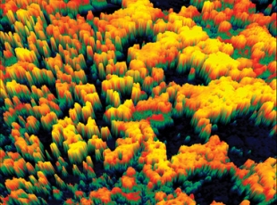
Enter the eye in the sky technology of some of the latest methods using airborne laser scanners, known as Lidar, short for “light detection and ranging”.
The variety of uses that can be made of this imagery is quickly expanding.
In Forests NSW it is being tested to show tree heights and to accurately determine features such as drainage lines, roads and slopes to assist in harvest planning and increasingly in the actual mechanical harvesting operation.
“Traditional methods have produced some errant map accuracy, such as misaligned stream locations sometimes many metres from where they actually are,” said Forests NSW harvesting forester Paul McBain, who along with remote sensing specialist Dr Russell Turner, is evaluating the Lidar system.
“We have tested the Lidar images by actually surveying on the ground and determining such things as stream centre lines, stream banks, where supervising forestry officers would usually begin their measurements, and roads and other features.
“When we have compared field survey results with the data produced from the Lidar images, we have found their accuracy to be under 2m variance on the horizontal plane and 60cm to 70cm on the vertical plane.
“If we are talking about average tree heights of 30m or more in many stands, we are getting an accurate picture of where the tall trees are; where the streams are; we are even picking up old snig tracks that have cut small depressions in the ground in harvests from long ago.”
The value of this to the harvest planner is increasing the longer the research continues.
The information can be used to test whether there is sufficient timber to make a harvest in a particular area worthwhile, and if so, where roads should be constructed or repaired, and where stream boundaries will appear on the maps.
This in turn has a value if the maps are transferred to global positioning systems in harvesting machines, so that the operator has an immediate proximity indication of when he is approaching an area excluded from harvest.
“If this technology can be expanded to show us the difference between species of vegetation, we can get an even better knowledge of the inventory of timber we have in potential harvest areas,” Paul said.
There are other advantages, especially in reducing the preparation timefor harvest plans, but also in the reduction in physical presence on the ground for supervising forestry officers.
“There are also issues here with reduced exposure of our staff to in-field accidents as they often have to traverse difficult forest environments in steep terrain,” Paul said.
Forests NSW has bought some of the Lidar data, but increasingly more collaborative projects are emerging with local government, fire agencies and other state government agencies.
For Dr Turner, dealing with the huge scale of lidar datasets, often gigabytes in size, presents a challenge.
“Lidar sensors emit high-repetition, short-duration laser pulses at a target and measure the return reflection time to gauge target distance and bearing,” Russell said.
“In a matter of minutes, a lidar sensor mounted in an aircraft can collect millions of laser returns from the forest below.
“Lidar is similar in concept to radar, but uses laser light instead of microwave energy.
“Some of the projects we have been working on include extracting crown heights to predict dominant tree biomass within a Blackbutt (Eucalyptuspiluaris) regrowth stand on the Mid North Coast, and locating stands requiring thinning in river red gum forests in the Riverina.”
Digital elevation models and tree height mosaics have also bee ngenerated for more than 60 000 ha of river red gum forests in the Millewa, Koondrook and Perricoota forests, and a further 240 000 ha of White CypressPine forests near Baradine.
Western regional staff have since used these images to re-map road and drainage networks, locate stands requiring thinning and to assist with harvest planning.
Other interests in the Lidar data include investigating the potential application of remote sensing technologies for spatially mapping forest fuel characteristics for fire threat or to plan hazard reduction burning, and to map bell miner associated dieback.
“A review of the literature reveals new applications emerging related to canopy height, stand basal area, stand density, successional growth stage,vegetation classification, canopy cover, vertical and horizontal vegetation structure, change detection, height growth, fauna habitat, storm damage assessment, and regeneration survey,” Russell said.
“This list is rapidly expanding. The few key applications that FNSW have been actively investigating over the past seven years include topographic mapping, catchment management, wood resource assessment, carbon accounting, harvest planning, and forest health and fuel assessment.”
Email:
